Our feature OKI Wanna Know is your chance to get an answer to that question that's been bugging you for years. This time, we examine a West Side neighborhood with a unique name.
Listener Mike Wuerth is curious about part of Green Township — specifically, Dent. How did it get its name? Was it because of a depression in the ground? If so, is that depression a quarry? A meteor crater?
The vice president of the Green Township Historical Association says the name did, in fact, come from a low spot in the topography. Joe Flickinger says Dent wasn't the original name though.
"The name Dent came from a guy by the name of Charles Reemelin. Charles Reemelin was kind of a pretty big mover and shaker in Hamilton County in the 1850s, roughly all the way through to the 1870s and 1880s," he says.

Reemelin was a German immigrant who originally started a dry goods store Downtown before moving to Green Township, Flickinger says.
"He was very quickly elected to the Ohio House of Representatives and then, later on, the Ohio Senate. He was known for being a guy that people could go to and people could respect."
In short, Flickinger says Reemelin was the kind of guy who, when he spoke, people listened. Around 1850, he set up his farm near modern day Harrison Road, Johnson Road, and yes, Reemelin Road. The area was originally named for a local minister, the Reverend James Challens.
"When they established a post office in the area, they really didn't have much out there. They called the original postal area Challensville," Flickinger says. "After that, Charles Reemelin made the case that because of all the peaks and valleys and everything, it should be called Dent."
The name stuck, in part because Reemelin had some influence, and because there was a dent — a large depression that has a history a lot older than human habitation.
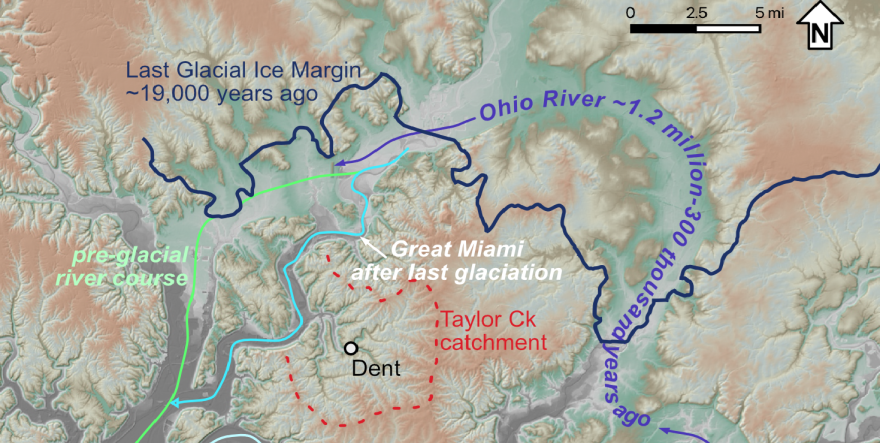
Dylan Ward is an associate professor of Geosciences at UC. He says the dent in Dent is from the area that drained into what we now call Taylor Creek.
RELATED: What are those dents in the ground in the Miami Whitewater Forest?
"The reason this catchment is deeper and a little bit bigger than its neighbors is because of where that creek joins the Great Miami (River), right around Miamitown," Ward says. "That part of the Great Miami was relocated by the last ice sheet."
Today, Taylor Creek joins the Great Miami River where I-275 crosses the river. But Dylan says about 19,000 years ago, the river was further west, on the other side of what is now Miami Whitewater Forest.

"Taylor Creek, or whatever that stream was prior to this event, it would have drained way across to the previous river position. It actually probably drained across where Miami Whitewater Forest is," he says.
But, the ice sheets redirected the Great Miami further east, near where it is now, and that affected Taylor Creek.
"Now, the stream is flowing to the same outlet elevation, but it's closer in. That shortens up the stream and makes it steeper, which means it erodes faster, and it begins to deepen."
Ward says that gives us the dent.
It wasn't just the Great Miami that changed course over time. The Little Miami River was rerouted by ice sheets at least once, and the Ohio River once flowed through what's called the Norwood Trough, and went further north.
"This area was occupied by ice sheets probably a dozen times or more over the last three million years. The last two of them are the clearest in the landscape. They are responsible for a whole lot of the way our river systems work. This area of Dent is just one little microcosm of the kinds of interactions between glaciers, rivers and the terrain around them."
RELATED: Why does Kentucky own the Ohio River?
Joe Flickinger with the Green Township Historical Association says another area also seems to have gotten its name from topography: Covedale
" 'The coves and the dales' is what it was usually described as," he says. "Let's put it this way, I think, unfortunately, when it came to the suburbanization aspect, Covedale sounded very neat. It sounded very nice when it came to selling some of the newer homes and things like that."


